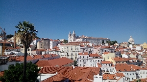
 Country on the south-western Europe. Located on the west part of the Iberian Peninsula, Portugal occupies an area of 92,152 km2. It is bordered by Spain on the east and north and by the Atlantic Ocean on the west and south.The Portuguese territory is divided in three parts: the mainland, the autonomous region of Madeira and Azores which have their own administration.
The mainland is divided into 18 administrative district : Viana do Castelo, Vila Real, Bragança, Braga, Porto, Aveiro, Viseu, Guarda, Coimbra, Castelo Branco, Leiria, Santarém, Portalegre, Lisbon, Setúbal, Évora, Beja and Faro; the districts are divided into municipalities (311), which are subdivided into civil parishes.
The autonomous region of Azores is an archipelago of 9 islands, divided in three groups: the western, the central and the eastern. The islands of Flores and Corvo are part of the western group, the islands of S. Jorge, Terceira, Faial and Pico are part of the central group and the islands of S. Miguel and Santa Maria are part of eastern group. The autonomous region of Madeira is an archipelago formed by the island of Madeira and Porto Santo.
The capital of Portugal is Lisbon. Other cities of more importance are Porto, Coimbra, Setúbal, Aveiro, Braga and Faro. The Portuguese terrain has several different forms. On the north of the Tejo river, it is very rough, with mountains, except the coast plain, and with an average height above 400 meters. These mountains are crossed by valleys and rivers.
On the south part of the Tejo river the terrain is formed by rolling plains, with low altitude, where the plains prevail. The highest mountains are located on the north of the Tejo river, and the most importants are Serra da Estrela (1991 m), Serra do Gerês (1508 m), Serra do Marão (1416 m), Serra do Montemuro (1381 m) and Serra do Caramulo (1075 m). On the south of the Tejo river, the most important mountains are Serra de São Mamede (1025 m), Serra do Monchique (902 m) and Serra do Caldeirão (577 m).
The rest of the Portuguese terrain is the coastline, which can be divided in three big set of plains: the Beira Litoral Plain formed by the alluvial plains of Vouga and Mondego, the Algarve Plain and the alluvial Plain of Tejo and Sado. The archipelagos of Azores and Madeira have theirs origins on volcanic activities and theirs terrains are very rough.
The coastline of Azores has a lot of cliffs and inside the islands the terrain is very mountainous. The highest mountain in Portugal is located inside the Pico island and it has 2351 meters. One characteristic of Madeira is that it has high mountains on the central part of the island.
The most important rivers are, from north to south of the mainland, the Minho, the Douro, the Tejo and the Guadiana all they rising in Spain and flowing to the Atlantic Ocean. Among the rivers whose course is Portuguese only, we have the Cávado, the Vouga, the Mondego, the Sado end Mira.
About The Author
Ilidio Lopes owns the site http://www.portugalturistic.com where you will find information on a variety of subjects relating to Portuguese territory.
Other important and suggested site links related to this article:
http://www.portugalturistic.com

 Country on the south-western Europe. Located on the west part of the Iberian Peninsula, Portugal occupies an area of 92,152 km2. It is bordered by Spain on the east and north and by the Atlantic Ocean on the west and south.The Portuguese territory is divided in three parts: the mainland, the autonomous region of Madeira and Azores which have their own administration.


